|
MAP
LIBRARY
|
WARNING:
Some of these maps are quite large and may take a few minutes to
download. Some may also cause your computer to lock up.
All maps have been reduced in weight, but not so much that the
quality of the graphic has been compromised. Please be patient.
|
* Download times are estimated for 28.8 modems. *
|
Map |
Graphic
Source |
Weight in Bytes |
Est. Time to Download* |
| Map
of
Iron Mountain;
shows most streets |
On site |
44,998 |
14.1 sec |
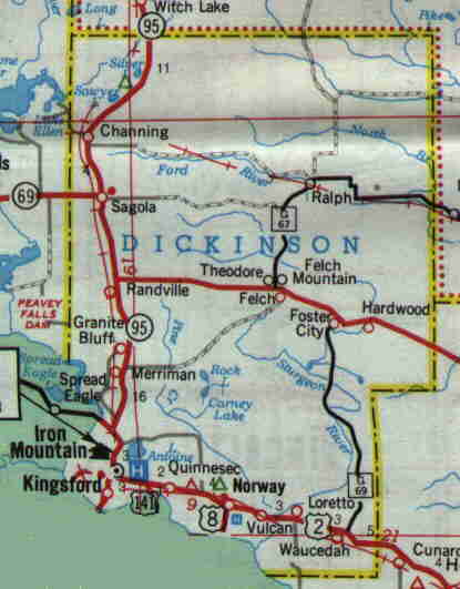
| Dickinson
County
villages, towns & cities
(county's major arteries shown) |
On site |
15,439 |
4.8 sec |
|
Current map
of
Dickinson
County |
On site |
21,819 |
6.8 sec |
|
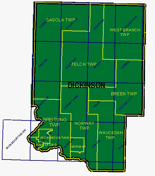
Geographic
frameworks of
Dickinson County's townships |
On site |
57,446 |
18.0 sec |
|
Topographical map
of Dickinson County showing how the towns sit within their
respective townships |
On site |
41,800 |
13.1 sec |
|
Michigan
1853 - HUGE! Pre-Dickinson when it was part of Delta and
Marquette Counties. |
Off site |
282,253 |
88.2 sec |
|
Michigan & Wisconsin
1861 - another HUGE one! Pre-Dickinson when it was part of
Marquette and Bleeker (now Menominee) Counties. |
On site |
190,829 |
59.6 sec |
| A
simple map of MI next to WI and showing principal
MI cities -
b/w |
On site |
33,195 |
10.6 sec |
|
Michigan's counties -
color |
Multi-Mag Magazine |
-- |
-- |
|
Michigan's counties
- b/w |
On site |
104,359 |
32.6 sec |
|
U.P.
counties in relation to Great Lakes & Wisconsin |
On site |
6,585 |
2.1 sec |
|
U.P. iron
districts - nothing else |
On site |
48,660 |
15.2 sec |
|
