 |
|
|
 |
|
|
|
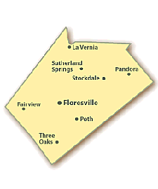
Wilson County Almanac
Wilson County is on the upper coastal plain of South Texas.
Four major highways serve the
county, U.S. highways 87 and 181 and State highways 97 and 123.
Transportation needs are also served by the Southern Pacific Railroad.
Wilson County covers 807 miles with an elevation of 300 to 600
feet above sea level. The terrain is nearly flat to gently undulating,
surfaced by deep loamy soils with clayey subsoils that support
grasses, mesquite, blackjack, post oak, live oak, thorny shrubs, and cacti.
The county consists of 809 square miles with a 2000 population density of
40.2 residents per square mile.
The average density in Texas is 79.6 persons per square mile which is the same
as the national average. Wilson County is the 83rd largest of the 254
counties in Texas, with an estimated population of 32,408 in 2000.
The western portion of the county is drained by
the San Antonio River, the eastern portion by Cibolo and Ecleto
creeks. The climate is subtropical sub-humid, with mild winters
and warm summers.
Crops include peanuts, hay, sorghum, oats,
wheat, corn, watermelons, peaches, and pecans. A watermelon jubilee is held each
June in Stockdale and a peanut festival is held each October in Floresville.
|
General information about Wilson County
Official Site:
Wilson County
Population: 36,726
Area: 807 sq. miles
County Seat: Floresville
Area Code(s): 830
Time Zone: Central
Founded 1860
- Land: 807 sq mi
- Water:
2 sq mi, 0.20%
Population
- (2000)
-
Density
32,408
41/sq mi (16/km²)
Wilson County was named for Somervell expedition member and legislator James C.
Wilson. This county is part of the San Antonio, TX Metropolitan
Statistical Area.
Between 31
and 40 percent of the land in the county
is considered prime farmland.
The
average growing season in Wilson County
is 280 days with the first freeze
generally occurring around December 1.
|
Farming
|
1987 |
1997 |
2007 |
|
Number of Farms |
1,746 |
1,794 |
2,570 |
|
Acres of Farmland |
448,022 |
445,798 |
467,187 |
|
Average Size of Farm (acres) |
257 |
248 |
182 |
Agriculture in Wilson County
Average size of farms: 207 acres
Average value of agricultural products sold per farm: $19799
Average value of crops sold per acre for harvested cropland: $101.24
The value of nursery, greenhouse, floriculture, and sod as a percentage of the
total market value of agricultural products sold: 3.02%
The value of livestock, poultry, and their products as a percentage of the total
market value of agricultural products sold: 82.21%
Average total farm production expenses per farm: $25423
Harvested cropland as a percentage of land in farms: 16.82%
Irrigated harvested cropland as a percentage of land in farms: 13.09%
Average market value of all machinery and equipment per farm: $36919
The percentage of farms operated by a family or individual: 93.97%
Average age of principal farm operators: 56 years
Average number of cattle and calves per 100 acres of all land in farms: 21.75
Milk cows as a percentage of all cattle and calves: 3.24%
Corn for grain: 9018 harvested acres
All wheat for grain: 3018 harvested acres
Soybeans for beans: 14 harvested acres
Vegetables: 684 harvested acres
Land in orchards: 638 acres
| 1870 |
2,556 |
1960 |
13,267 |
| 1880 |
7,118 |
1970 |
13,041 |
| 1890 |
10,655 |
1980 |
16.756 |
| 1900 |
13,961 |
1990 |
22.650 |
| 1910 |
17,066 |
2000 |
32,408 |
| 1920 |
17,289 |
2005 |
37,529 |
| 1930 |
17,606 |
2008 |
40,398 |
| 1940 |
17,066 |
2009 |
36,726 |
| 1950 |
14,672 |
|
|
|
Wilson County historical area-adjusted tornado activity is significantly
below Texas state average. It is 2.0 times below overall U.S. average.
Temperatures in January range from an average low of 40° to an average high
of 65° F and in July range from 74° to 96° F.
Rainfall in Wilson County averages 29.4 inches per year as
compared to the Texas average of 28.1 inches per year.
Wilson
County Occupations
The county civilian labor force of Wilson County in 2001 shows the following:
| Industry |
Jobs |
Percentage |
| Natural Resources & Mining |
180 |
3% |
| Construction |
285 |
6% |
| Manufacturing |
311 |
5% |
| Trade, Transportation & Utilities |
1,005 |
20% |
| Information |
71 |
1% |
| Financial Activities |
90 |
2% |
| Professional & Business Services |
175 |
3% |
| Education & Health Services |
811 |
16% |
| Leisure & Hospitality |
341 |
7% |
| Other Services |
93 |
2% |
| Nonclassifiable |
0 |
0% |
| Federal Government |
58 |
1% |
| State Government |
83 |
2% |
| Local Government |
1,707 |
34% |
|

Adjacent counties
|
Distances from the county seat
of Floresville (Miles) |
|
Austin
|
84 |
|
Amarillo
|
471 |
|
Brownsville
|
226 |
|
Dallas
|
266 |
|
El Paso
|
528 |
|
Houston
|
172 |
|
|
|
|
|
|
|